
Messerli, Bruno; Zurbuchen, Max; Indermühle, Daniel (1972). Emi Koussi - Tibesti: Eine topographische Karte vom höchsten Berg der Sahara. In: Arbeitsberichte aus der Forschungsstation Bardai/Tibesti III - Feldarbeiten 1966/67. Berliner geographische Abhandlungen: Vol. 16 (pp. 117-123). Berlin: Geographisches Institut der Freien Universität Berlin 10.23689/fidgeo-2849
|
Text
Messerli_et_al._1972_Emi_Koussi.pdf - Published Version Available under License Creative Commons: Attribution (CC-BY). Download (14MB) | Preview |
|
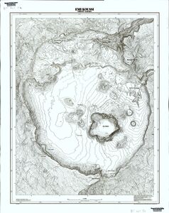
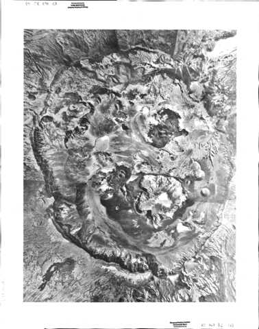
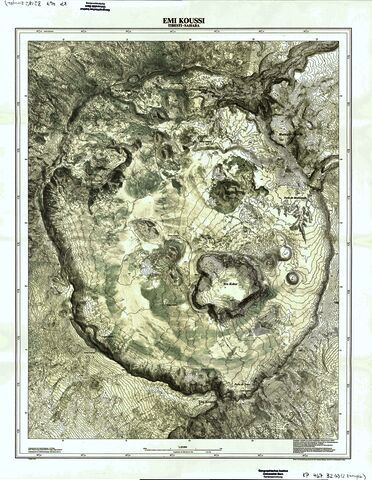
![[img]](https://boris.unibe.ch/185875/8/Messerli_et_al._1969_Emi_Koussi_Relief.jpg)
|
Image
Messerli_et_al._1969_Emi_Koussi_Relief.jpg - Supplemental Material Available under License Creative Commons: Attribution (CC-BY). Download (7MB) | Preview |
|
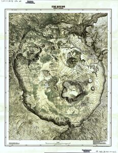
![[img]](https://boris.unibe.ch/185875/9/Messerli_et_al._1969_Emi_Koussi_H_henlinien.jpg)
|
Image
Messerli_et_al._1969_Emi_Koussi_H_henlinien.jpg - Supplemental Material Available under License Creative Commons: Attribution (CC-BY). Download (10MB) | Preview |
|
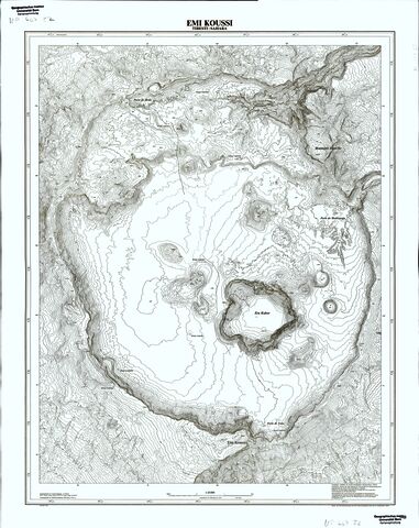
![[img]](https://boris.unibe.ch/185875/10/Messerli_et_al._1969_Emi_Koussi_Kombination.jpg)
|
Image
Messerli_et_al._1969_Emi_Koussi_Kombination.jpg - Supplemental Material Available under License Creative Commons: Attribution (CC-BY). Download (11MB) | Preview |

Item Type: |
Book Section (Book Chapter) |
|---|---|
Division/Institute: |
08 Faculty of Science > Institute of Geography 08 Faculty of Science > Institute of Geography > Physical Geography |
UniBE Contributor: |
Messerli, Bruno |
Subjects: |
900 History > 910 Geography & travel |
Series: |
Berliner geographische Abhandlungen |
Publisher: |
Geographisches Institut der Freien Universität Berlin |
Language: |
German |
Submitter: |
Thomas Jürg Reist |
Date Deposited: |
30 Aug 2023 13:12 |
Last Modified: |
06 Sep 2023 12:16 |
Publisher DOI: |
10.23689/fidgeo-2849 |
Related URLs: |
|
BORIS DOI: |
10.48350/185875 |
URI: |
https://boris.unibe.ch/id/eprint/185875 |
Actions (login required)
 |
Edit item |