
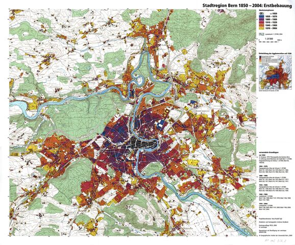
Egli, Hans-Rudolf (2009). Stadtregion Bern 1850–2004: Erstbebauung [Map]. In: Kartensammlung GIUB (KP 143 D26). Bern: Geographisches Institut der Universität Bern
![[img]](https://boris.unibe.ch/197560/1/Egli_2009_Stadtregion_Bern_1850-2004.jpg)
|
Image
Egli_2009_Stadtregion_Bern_1850-2004.jpg - Published Version Available under License Creative Commons: Attribution-Noncommercial (CC-BY-NC). Download (9MB) | Preview |

Item Type: |
Audiovisual Material & Event (Map) |
|---|---|
Division/Institute: |
08 Faculty of Science > Institute of Geography |
UniBE Contributor: |
Egli, Hans-Rudolf |
Subjects: |
900 History > 910 Geography & travel |
Publisher: |
Geographisches Institut der Universität Bern |
Language: |
German |
Submitter: |
Thomas Jürg Reist |
Date Deposited: |
05 Jun 2024 15:49 |
Last Modified: |
05 Jun 2024 15:49 |
Related URLs: |
|
Additional Information: |
Frühere Versionen der Karte: |
BORIS DOI: |
10.48350/197560 |
URI: |
https://boris.unibe.ch/id/eprint/197560 |
Actions (login required)
 |
Edit item |

