
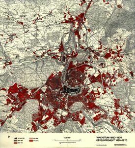
Grosjean, Georges; Mäder, Charles (1972). Développement 1850–1970 [Map]. In: Kartensammlung GIUB (KP 143 D30). Bern: Geographisches Institut der Universität Bern
![[img]](https://boris.unibe.ch/199555/1/KP_143_D30_Grosjean_1972_Bern_Wachstum_1850-1970.jpg)
|
Image
KP_143_D30_Grosjean_1972_Bern_Wachstum_1850-1970.jpg - Published Version Available under License Creative Commons: Attribution-Noncommercial (CC-BY-NC). Download (8MB) | Preview |
Item Type: |
Audiovisual Material & Event (Map) |
|---|---|
Division/Institute: |
08 Faculty of Science > Institute of Geography |
Subjects: |
900 History > 910 Geography & travel |
Publisher: |
Geographisches Institut der Universität Bern |
Language: |
German |
Submitter: |
Thomas Jürg Reist |
Date Deposited: |
07 Aug 2024 16:56 |
Last Modified: |
07 Aug 2024 16:56 |
Related URLs: |
|
Additional Information: |
Georges Grosjean (1921–2002) war von 1963 bis 1986 Professor für Kultur- und Wirtschaftsgeographie an der Universität Bern. Die Karte ist als Beilage erschienen in: Grosjean, Georges (1973). Kanton Bern – historische Planungsgrundlagen. Bern: Kommissionsverlag Kümmerly & Frey |
Uncontrolled Keywords: |
Stadt Bern |
BORIS DOI: |
10.48350/199555 |
URI: |
https://boris.unibe.ch/id/eprint/199555 |
Actions (login required)
 |
Edit item |